Sturgeon River Sloughs
|
|
Viewing of some maps requires Adobe Acrobat. Download a free copy of it here. |
|
Sturgeon River Sloughs
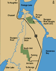
Size:2,800 Acres Directions:From Chassell, drive south on US-41 about one mile to the North Unit parking lot entrance on the left side of the road. Drive another 6 miles south on US-41 and turn right on Arnheim Road, then drive about 1 mile west to the South Unit access road. There are 2 parking lots located along this road. Description:This site has two separate land management units; a North Unit, located just off US-41, and a South Unit, located 1 mile west of US-41 off of Arnheim Road. This site provides a wonderful look at the wetlands associated with the Portage and Sturgeon Rivers. An observation tower adjacent to the parking area gives visitors a panoramic view of this wildlife area. A 1.5-mile nature trail and boardwalk begins at the parking area. |
|
Wildlife Viewing:This wildlife area is enhanced with earthen dikes that allow wildlife biologists to raise and lower water levels for the benefit of waterfowl, shorebirds, and other wetland wildlife. There are fields with food plots and grassy cover for foraging and nesting. In addition to the ducks and geese found here, it is common to see great blue herons, bald eagles, marsh hawks, sandhill cranes, and ospreys in and around this attractive wetland area. Beavers, muskrats, mink, black bears, and white-tailed deer also make their homes here and are best viewed at dawn and dusk. This area is open to public hunting, except for the diked area of the north unit. See the Michigan Department of Natural Resources web site for seasons and a detailed map. View/Download the map of the Sturgeon River Sloughs Information courtesy of the Department of Natural Resources |
|