Haywire Grade Trail
|
|
Viewing of some maps requires Adobe Acrobat. Download a free copy of it here. |
|
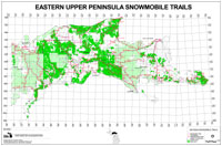
Haywire Grade Trail: 37 miles - Snowmobile Trail
The Haywire Grade Trail covers about 10 miles within the Rapid River/Manistique District, but has an overall length of around 37 miles including the Munising District, State Forest and private land. Access to the Manistique portion is in Manistique. Many users, however, enter the trail from the "s" curves on M-94 which is about six miles north of town. Food, telephone and fuel are available along the trail at Steuben and Shingleton. Information courtesy of USDA Forest Service. Haywire Grade Trail: - ATV Trail
The Haywire Trail begins on M-94 south of Shingleton and ends at the Water Intake Plant in Manistique, traveling on 33 miles of dirt, gravel, sand and original ballast. Throughout the year, the trail is used by snowmobiles, all terrain vehicles, mountain bikes, and horseback riders. Motorized use is the most common use. The main trailheads at either end of the trail provide parking areas for trail users. Northern Trailhead: Located just south of Shingleton, a sign marks the northern trailhead on the east side ofM-94. There is no parking at the trailhead, but spaces may be available at or near local businesses on M-28 in Shingleton, less than 1/3 mile north of the trailhead. |
|
|
View Larger Map Southern Trailhead: The southern trailhead is located just north of Manistique off ofM-94. Turn east on Riverview Road, following it to the parking area just beyond the Water Intake Plant. In addition to parking, you will find a small picnic area with barbecue grills. Trail Distance:33+ Miles Trail Description and HistoryYou're in beaver country, so plan on getting your feet wet This adventurous rail-to-trail wanders through miles of wetlands, crosses fourteen small bridges (but only six roads), and plows through a few merciless sand traps. Those undaunted by the occasional washout or water over the trail will be rewarded, not only with wet shoes and socks, but by the serenity of the Hiawatha National and Lake Superior State Forests through which the trail meanders. While it's not wet enough to require a ferry to navigate along the trail, ferries played an important role in the corridor's past. After the rail-line was constructed in 1902, the Ann Arbor Railroad began to ferry rail cars to Manistique from Frankfort. Ten years earlier the Ann Arbor made railroad history by . becoming the first company to operate a car ferry across open water. Abandoned after 66 years, this corridor became Michigan's fIrSt rail-trail when Schoolcraft County purchased it. This gave the U.S. Forest Service and the Department of Natural Resources sufficient time to eventually acquire it themselves in 1970. Northern Trailhead to M-94 (first crossing) (1.3 miles) After the corridor was purchased, part of it was reserved to maintain access to the active east /~st rail line at Shingleton. This made it necessary to cut a 0.3 mile connector from the corridor to M-94 establish a trailhead. Angling toward the old rail grade, the first 0.3 miles has ruts and may be seasonally wet. Mountain bikers, be prepared to walk. An alternative for some would be to stay on M-94 (which has a 3-foot paved shoulder) for 1.3 mile and pick up the trail where it first crosses the highway. M-94 crossing to Steuben (11.6 miles) Mountain bikers should be able to navigate the trail to Steuben even though at times it is sandy or periodically covered by water due to beaver activity. This segment of trail crosses one road, contains eleven bridges, and briefly borders the Big Island Lake Wilderness. Steuben to Trail via Bypass (2.5 miles) the section of trail south of Steuben is occasionally washed away by beavers and is then temporarily closed. The best alternate route is to take the Thunder lake Road (County Rd 437) east 1.5 miles to M-94 and then south one mile to where the trail again crosses the highway. Not only will this bypass the temporary beaver damage, but it gets you past the deep sand found along this section of the trail. M-94 (2Dd crossing) to M94 (3rd crossing) (x miles) Once back on the grade, the trail becomes a hard-packed two-track that passes through a recently logged area. About 1.5 miles for the second M-94 crossing another trail veers off to the right, leading to Indian River Camp and Picnic Grounds one mile away. M-94 (3rd crossing) to M-94 (4th crossing). About 4.4 miles beyond the third M-94 crossing is a large wet area with hunks of gravel fill. About 0.3 miles later, near the Hiawatha Station, a sandy stretch may give some trail users problems. M-94 (4th crossing) to Southern Trailhead (6.3 miles) about 1.7 miles after the fourth M -94 crossing, a two-track service-drive intersects the trail. (If you head west 0.8 miles on this service-drive you will find a snowmobile parking area offM-94 that is 4.5 miles from Manistique.) Continuing along the trail past service-drive, it is only 4.6 miles to the Southern Trailhead. About 3.7 miles past the service-drive, a snowmobile trail takes a sharp left away from the corridor. Don't be tempted to take this. Trail SafetyPlease keep in mind that this is a multi-purpose motorized trail. Be prepared to meet ATV's, mountain bikes, snowmobiles and others depending on the season. Trail users should maintain control of their speed at all times and approach turns in anticipation of someone around the bend. Information courtesy of USDA Forest Service. View and Download this Map (Snowmobile) View and Download this Map (ATV) Return to Delta County, Michigan Trails |
|