


 |
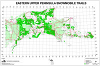
Coal Wood Trail: 10 miles - Snowmobile Trail

The Coal Wood Trail is located approximately 8 miles southwest of Munising on M-94. This east-west running trail connects the North Hiawatha Trail with the Haywire Grade located to the east in Shingleton. Services available in Shingleton include phone, fuel, groceries, bar and restaurant. This trail also provides access to the Baldy Lake Trail, located 1 mile east of M-94, southwest of Munising.
Information courtesy of USDA Forest Service.
View Larger Map |
Coal Wood Trail: 14 miles - ATV Trail

The Coalwood Trail begins on M-94 south of Shingleton and ends at Stillman. Covering 14 miles of hard packed surface, segments of the trail are open to different users, including ORVs, mountain bikers, and pedestrians.
East Trailhead:
Located just south of Shingleton, a sign marks the eastern trailhead on the west side of M-94. There is no parking at the Trailhead, but spaces may be available at or near one of the business on M-28 in Shingleton, less than Va-mile north of the trailhead.
West Trailhead:
The Stillman trailhead is located on the west side of M-94 West, about 6 miles from the M-28/M-94 intersection. Limited parking is available along the Stillman Road. This trailhead also serves the Haywire Grade Motorized Trail.
Trail Description and History
The trail offers a pleasant ride through northern hardwood and red pine stands, crossing a number of two-track roads and Forest Highway 13 as it makes its way between Hwy M-94 East and Hwy M-94 West. The trail, which follows an old railroad grade, is well marked and easily followed.
Trail Safety
Please keep in mind that this is a multi-purpose motorized trail. Be prepared to meet ATVs, mountain bikes, snowmobiles and others depending on the season. Trail users should maintain control of their speed at all times and approach turns in anticipation of someone around the bend.
ORV Operation is Prohibited on . . .
- In any forest nursery or planting area
- On a DNR dedicated natural area
- In any area in a manner to injure, damage or destroy crops or trees
- In any area in a manner so as to crate an erosive condition
- Within 100 feet of a dwelling at a speed greater than the minimum speed necessary for controlled forward movement, except:
- On private property. On designated routes, trails, areas or access routes
- On lands of another without permission
- Within 100 feet of a slide, ski or skating area
- On any operational or non-abandoned railroad right-of-way (except to cross at designated railroad crossing)
- In or upon the waters of any stream, river, bog, wetland, marsh or quagmire
- In public hunting areas during the November firearm deer season, between the hours of 7:00 AM and 11:00 AM, and 2:00 PM and 5:00 PM, except for: going to or from a residence or hunting camp that is inaccessible by a conventional vehicle (subject to state land regulations). On private property, with landowners permission. Passenger vehicles while being operated on roads capable of sustaining automobile traffic. A person holding a Permit to Hunt from a standing vehicle or other persons meeting disabled requirements while engaged in hunting or fishing activity
- On any public highway, street or right-of-way except: to cross at right angles, after a complete stop (not on limited access freeways) for ORVs, also registered as motor vehicles under the Michigan Vehicle Code, In a special event held under a government permit
- At a rate of speed greater than that which is reasonable and proper
- In a careless manner without due regard for existing conditions
- In a manner to leave litter or debris
- In a hunting, pursuing or worrying any animal
- While transporting or possessing an alcoholic beverage that is open or uncapped (seal has been broken)
- While transporting a strung, uncased bow or and uncased or loaded firearm
- While under the influence of alcohol or a controlled substance
- While visibly impaired due to alcohol or a controlled substance
- While transporting a passenger without a seat as designed by the manufacturer
- While under a court suspension of ORV or automobile operating rights
- On any unlicensed ORV
View and Download this Map (Snowmobile Trail)
View and Download this Map (ATV Trail)
Return to Schoolcraft County, Michigan Trails
Return to Alger County, Michigan Trails
|